
BTS Updates Datasets to National Transportation Atlas Database
The U.S. Department of Transportation’s Bureau of Transportation Statistics today released its spring 2022 update to the National Transportation Atlas Database (NTAD), a set of nationwide geographic databases of transportation facilities, networks, and associated infrastructure.
The updated layers in this release include:
- Alternative Fuel Corridors;
- Alternative Fueling Stations;
- Intermodal Passenger Connectivity Database (IPCD);
- Bikeshare;
- Bikeshare Scooter Systems;
- Fatality Analysis Reporting System (FARS) 2021 Data;
- Congressional Districts – Updated 117th Congressional Members;
- 2021 Aggregated Airline Traffic Data by Origin and Destination;
- Nonattainment Areas;
- National Parks;
- Marine Highways;
- 2021 Travel Monitoring Analysis System (TMAS) Station and Volume Data;
- Freight Analysis Framework (FAF5) for base year 2017 and data forecasted up to 2050;
- FAF5 Network Lines;
- FAF5 Network Nodes;
- FAF5 Regions;
- North American Rail Network Lines;
- North American Rail Network Nodes;
- Railroad Grade Crossings;
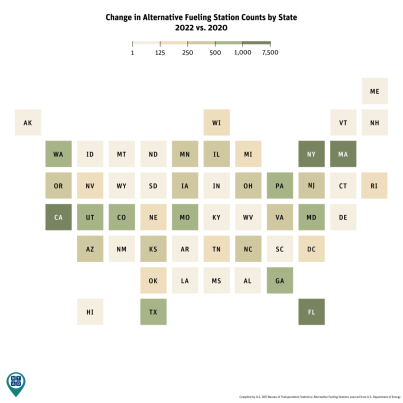
The alternative fuel station infrastructure will play an increasingly important role as the nation continues to transition to alternative fuel vehicles. Over the last two years from April 1, 2020 to April 1, 2022, the number of open and usable alternative fueling stations have increased nationally by more than 20,000. These stations accommodate and include biodiesel, compressed natural gas, ethanol (E85), electric, hydrogen, liquefied natural gas (LNG), and liquefied petroleum gas (propane). California, Massachusetts, New York and Florida had the largest increases, each adding more than a thousand stations.
About the National Transportation Atlas Database (NTAD)
NTAD data is available for download in comma separated values (CSV), Keyhole Markup Language (KML), and shapefile formats through the BTS Geospatial Data Catalog. Additionally, Open Geospatial Consortium (OGC) standard Web Feature Services (WFS) and Web Mapping Services (WMS) are available for all NTAD datasets, here and here. Also available are optimized services for fast rendering of full NTAD datasets and vector tile services for 13 of the largest NTAD datasets. These faster services are designated in NTAD by service names ending in “DS” for each layer and “VT” for the vector tiles services.
BTS now uses a dynamic NTAD publication cycle, with updated data released throughout the year as they become available from their respective government agencies. Follow BTS on Twitter, LinkedIn, and Instagram or subscribe to email updates for announcements of additional dataset releases throughout the year.
Contacts
Media: BTSNews@dot.gov.
Technical: Dominic Menegus: (202) 366-8717 or ntad@dot.gov.