BTS Updates Datasets to National Transportation Atlas Database 02/09/2024
The U.S. Department of Transportation’s (USDOT) Bureau of Transportation Statistics (BTS) today released its winter 2024 update to the National Transportation Atlas Database (NTAD), a set of nationwide geographic databases of transportation facilities, networks, and associated infrastructure.
With this data release, four (4) new layers have been added to the NTAD. These include layers for the National Highway Freight Network (NHFN), the 1991 Federal Aid Primary (FAP) Roads, and the National Highway System (NHS) along with a view layer of the NHS showing the Strategic Highway Network (STRAHNET).
The updated layers in this release include:
- National Parks;
- Marine Highways;
- 118th Congressional Districts – attributes updated weekly;
- Alternative Fueling Stations – updated daily;
- Metropolitan Planning Organization (MPO);
- Inland Electronic Navigational Charts;
- Dams – updated weekly;
- Aviation Facilities – updated monthly;
- Runways – updated monthly;
- Nonattainment Areas;
- Intercity Bus Atlas;
- National Transit Map Stops;
- National Transit Map Routes;
- National Transit Map Agencies;
- Military Bases;
- North American Rail Network Lines;
- North American Rail Network Nodes;
- Railroad Grade Crossings;
- Amtrak Routes;
- State Boundaries;
- County Boundaries;
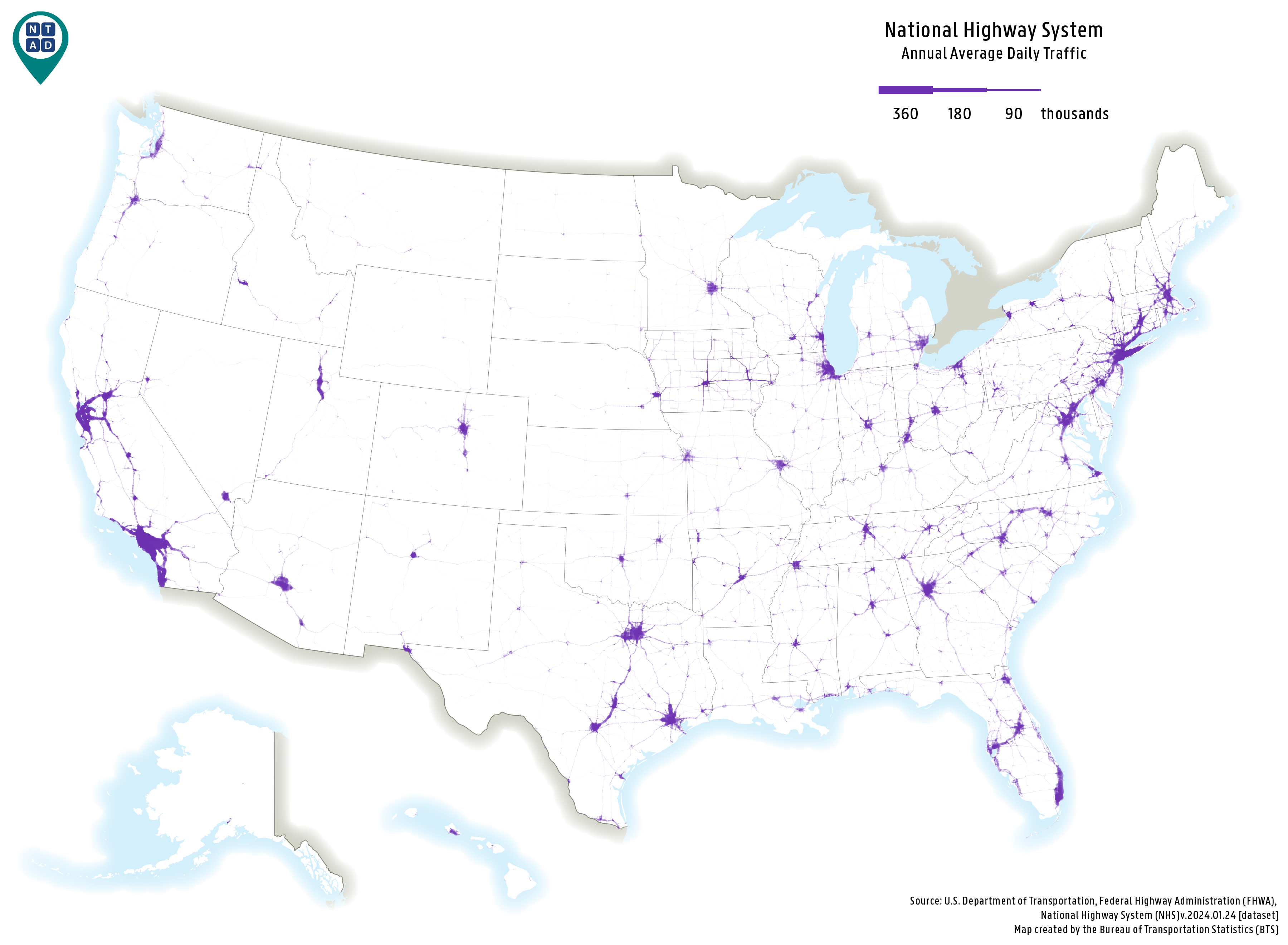
The map below depicts the annual average daily traffic (AADT) throughout the National Highway System (NHS), sourced from the Federal Highway Administration (FHWA). The NHS includes the Interstate Highway System as well as other roads important to the nation’s economy, defense, and mobility. The NHS was developed by the Department of Transportation (DOT) in cooperation with the states, local officials, and metropolitan planning organizations (MPOs). Segments with high AADT are found predominately in urban centers and roadways connecting major metropolitan areas in the contiguous U.S.

About the National Transportation Atlas Database
NTAD data is available for download in comma separated values (CSV), Keyhole Markup Language (KML), Shapefile, GeoJSON, and File Geodatabase formats through the BTS Geospatial Data Catalog. Additionally, Web Feature Services (WFS) are available for NTAD datasets here, designated in NTAD by service names ending in “DS.” Also available are optimized services for faster rendering via vector tile services for 13 of the largest NTAD datasets designated in NTAD by service names ending in “VT.”
BTS now uses a dynamic NTAD publication cycle, with updated data released throughout the year as they become available from their respective government agencies. Follow BTS on Twitter, LinkedIn, and Instagram or subscribe to email updates for announcements of additional dataset releases throughout the year.
Contacts
Technical: Dominic Menegus: (202) 306-1587 or ntad@dot.gov.
