U.S. Transportation Wall Map Released
DOT 03-17
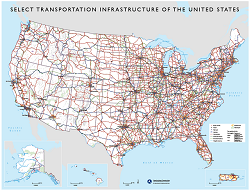
Friday, January 6, 2017 – The Bureau of Transportation Statistics (BTS) has released a newly updated double-sided wall map, Transportation Geography of the United States. The front of this map features a reference map of select U.S. transportation infrastructure and connections, including the National Highway System (NHS), class I railroads, airports with at least 750,000 enplanements, major ports with a commodity tonnage total of 10 million or more, and border crossings on the NHS. On the back, multiple dimensions of transportation, addressing passenger and freight movement, are highlighted featuring the latest statistics through a variety of cartographic methods. These thematic maps represent a variety of modes in the areas of safety, performance, usage, and system extent and provide a national level picture of transportation infrastructure in the U.S. To order a print copy of the Transportation Geography of the United States map, go to the BTS publications page. This guide can also be obtained by contacting BTS by phone at 202-366-DATA, by e-mail at BTSorders@dot.gov. For a digital copy, visit Map Gallery.